Water/Wastewater
Interactive oil spill map reveals threat to uk ocean wildlife
Feb 19 2025
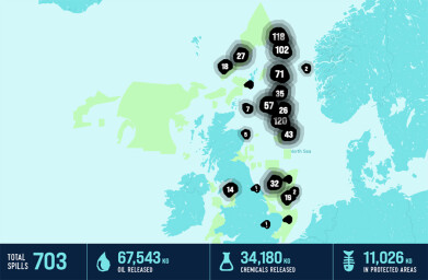
A new interactive map created by Oceana UK has exposed the alarming scale of toxic pollution in UK seas, revealing that the country’s waters endured over two oil or chemical spills per day last year, totaling more than 82,000 kg of oil and 149,700 kg of chemicals. This is the first time such data has been gathered in one place, drawing live information from government databases that have previously been scattered and difficult to access.
Revealing the impact of toxic chemical spills
One of the most concerning spills occurred in the Alba oil field off northeast Scotland in August 2024, where a chemical spill released 11,170 kg of toxic substances, including 2,800 kg of a biocide described as “very toxic to aquatic life with long-lasting effects.” The spill took place near an area known for high densities of wildlife, including minke and killer whales, white-beaked dolphins, and the declining harbour porpoise. Alarmingly, this incident occurred just 25 km from a marine protected area.
Despite the seriousness of the spill, no formal investigation has been initiated, and the government has not responded to a Freedom of Information request from Oceana UK seeking details of any enforcement actions or measures taken. Oceana UK has now filed a complaint with the Information Commissioner's Office regarding the lack of transparency.
Toxic pollution’s impact on marine life
Marine wildlife exposed to such toxic spills are at risk of direct contamination through skin contact, feeding, or inhaling harmful vapors. Studies have shown that contamination from oil and gas activities leads to a variety of health issues in marine species, from lung disease in dolphins to cancers in seabirds and reproductive disruptions in fish.
Underreported spill data reveals worse situation
Oceana UK warns that the true scale of pollution is likely even higher than the map suggests due to inadequate self-reporting by oil companies. Nearly a third (32%) of permit breach reports between January 21 and May 24 failed to provide details on the volume of oil spilled, meaning the level of pollution is underreported.
Naomi Tilley, Oceana UK’s Oil & Gas Campaign Lead, stated, “The toxic pollution revealed by this map should be making headlines – but for years, oil companies have used UK waters as a dumping ground with little public scrutiny. We urge everyone who cares about our oceans to use the map to help expose this hidden disaster. The data makes it clear: the oil and gas industry cannot be trusted to safeguard UK seas. It’s time for the government to implement a permanent ban on all new oil and gas drilling.”
Public concern and lack of enforcement
Oceana's polling has shown that 71% of UK adults do not trust regulators to protect marine wildlife from oil and gas drilling. Furthermore, Oceana’s 2024 report highlighted that enforcement remains weak, with only two recorded convictions or fines in the past five years, one of which was a mere £7,000.
The launch of this interactive map empowers the public to investigate individual spills, hold companies accountable, and demand stronger government action to protect marine ecosystems from the ongoing threat of oil and chemical pollution.


-from-Landia-are-on-their-way-to-Estonia.jpg)


Events
Aug 24 2025 Stockholm, Sweden and online
Aug 27 2025 Busan, South Korea
Sep 02 2025 Mexico City, Mexico
Sep 02 2025 Mexico City, Mexico
Sep 09 2025 Moscow, Russia